- Home
- Dashboard
Dashboard
For the city of Ghent, a new MATSim model was developed based on the three-annual travel survey the city organises. These travel diaries were used as input for the model. We did this for data from 2015, with 1500 respondents, from 2018, with 3000 respondents, and from 2021, with 1500 respondents. For this dashboard, only the simulation data for 2018 is shown.
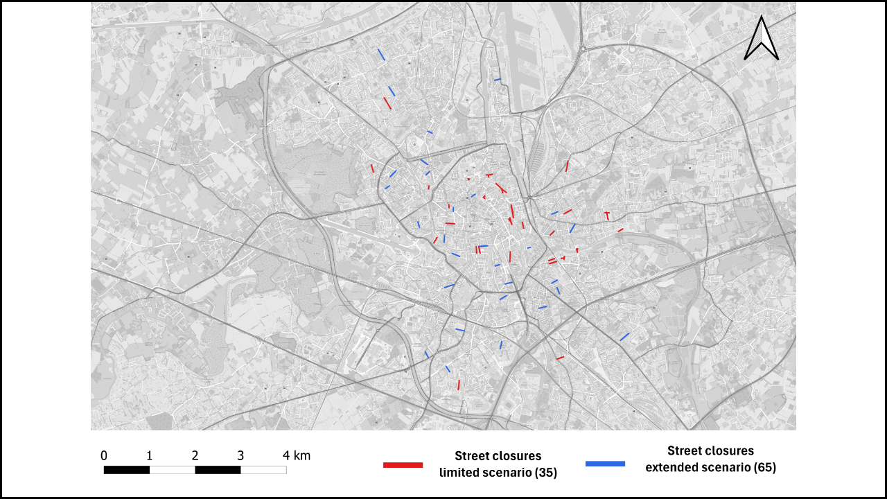
The scenarios with street closures are based on the real-life programme Living Street or "leefstraten" in Ghent (Belgium). Each year, residents can organise themselves and apply for a street closure in their street during the summer months. We used the interventions of the past several years in our model, resulting in a total of 35 street closures across the city. For the extreme scenario, we added an additional 30 street closures.
General results
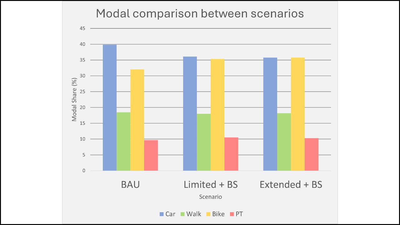
We can see that the street closures create a shift in car traffic from the city centre towards the ring roads, both the inner ring road (R40) as the outer ring road (R4), specifically for key-points that provide access to the ring roads. Implementing street closures result in an overall decrease of car traffic and increase in bicycle traffic. This is even more so when implementing a higher amount of street closures.
For the bike-sharing scenario, we see a similar result, leading to an increase in bicycle traffic and a decrease in car traffic. The opposite is true for adding car-sharing stations.
Ghent City Workshop
To test the scenarios, we organised a workshop with the City of Ghent. We invited mobility experts and transport planners to evaluate the use of the scenarios presented and create new hypothetical scenarios of interest to the city.
Relevant links:
Street closures
Street closures
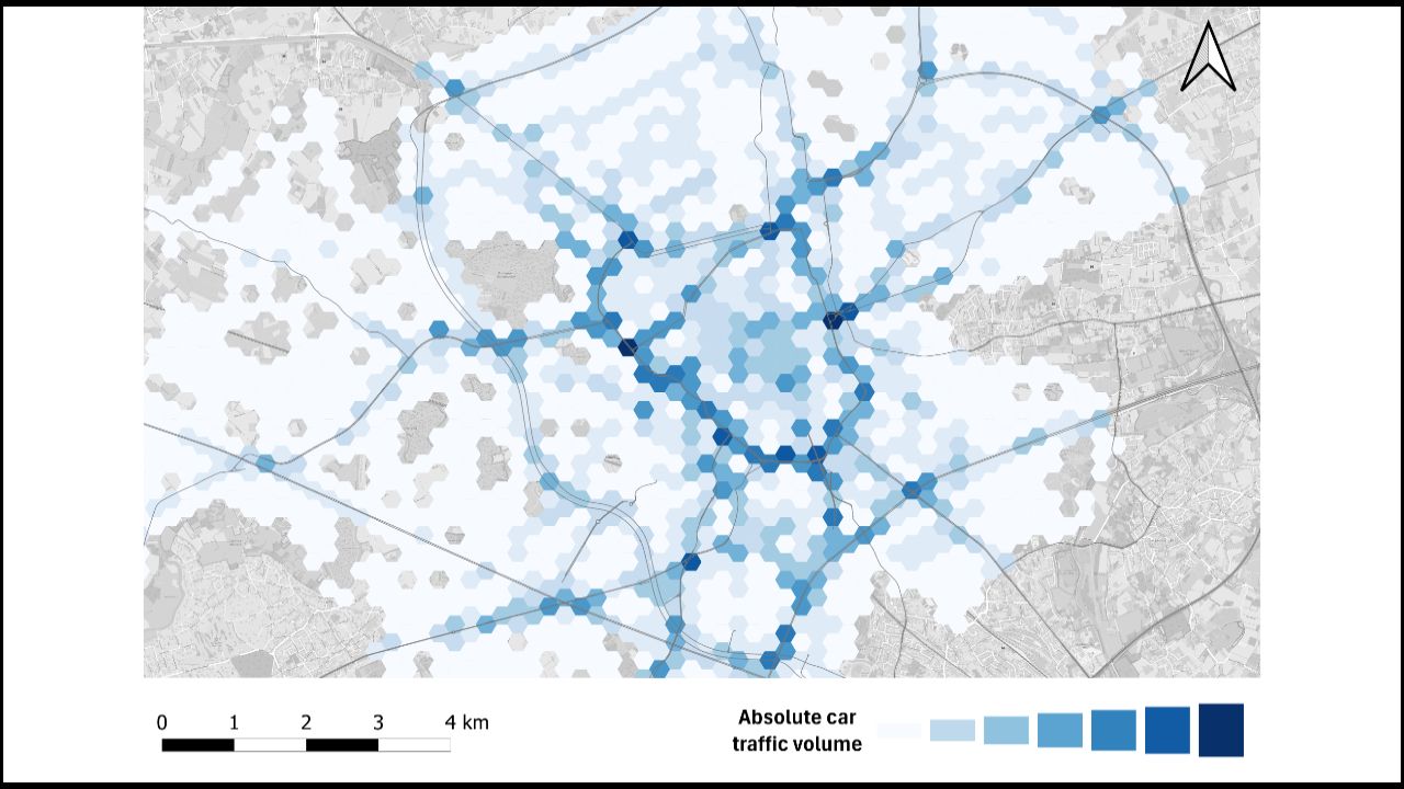
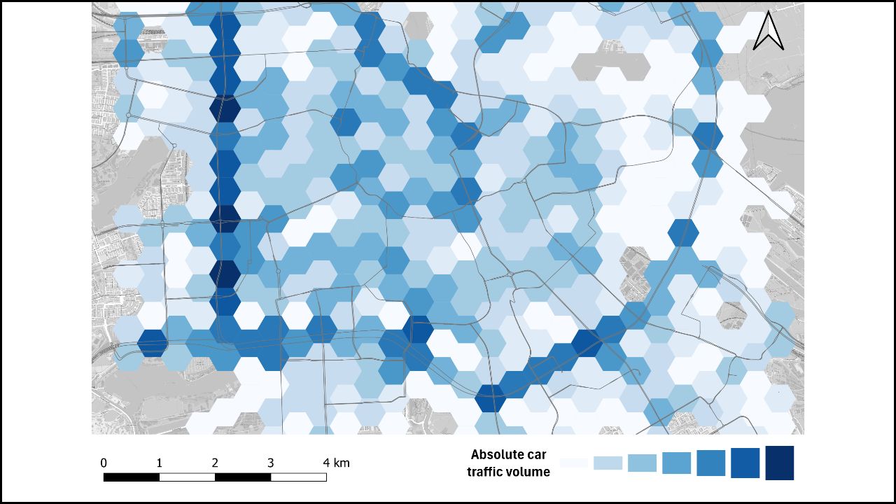
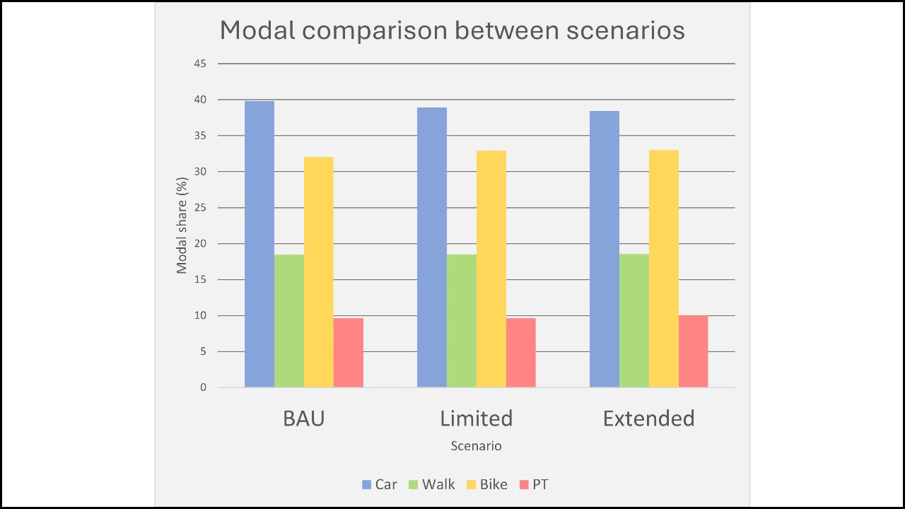
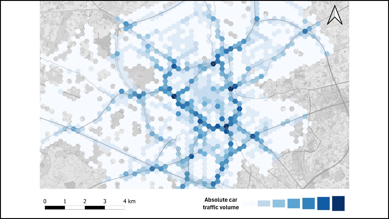
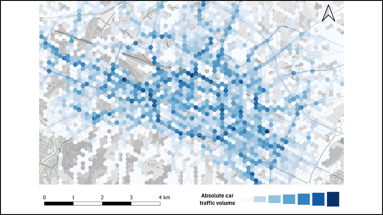
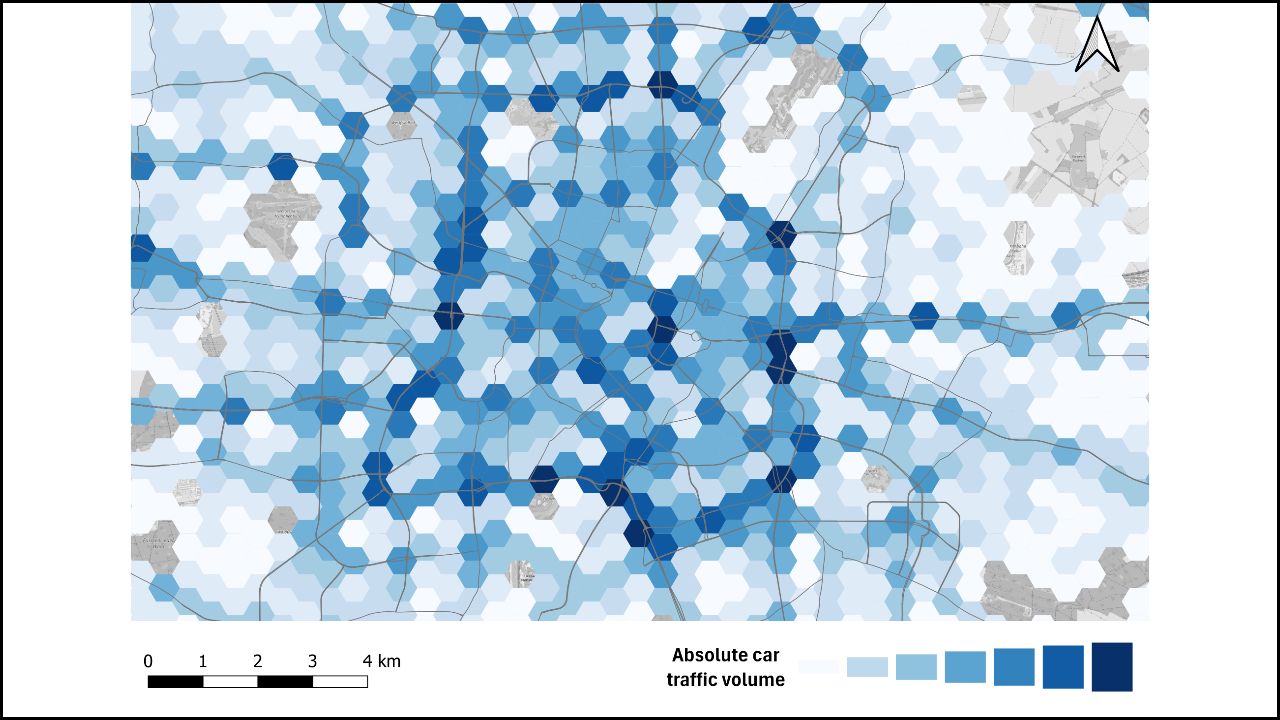
We can see here in dark blue where car traffic is present. Since the data is only from people living in Ghent, we can see that the inner ring road (R40) has most car traffic, together with some other arterial roads and the outer ring road. The modal split here is: 43% cars, 31% bicycle, 16% walking, and 10% public transport.
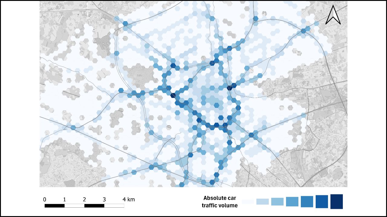

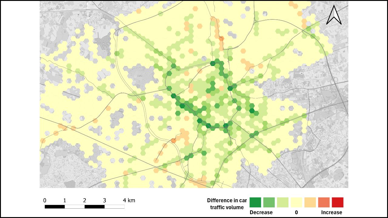
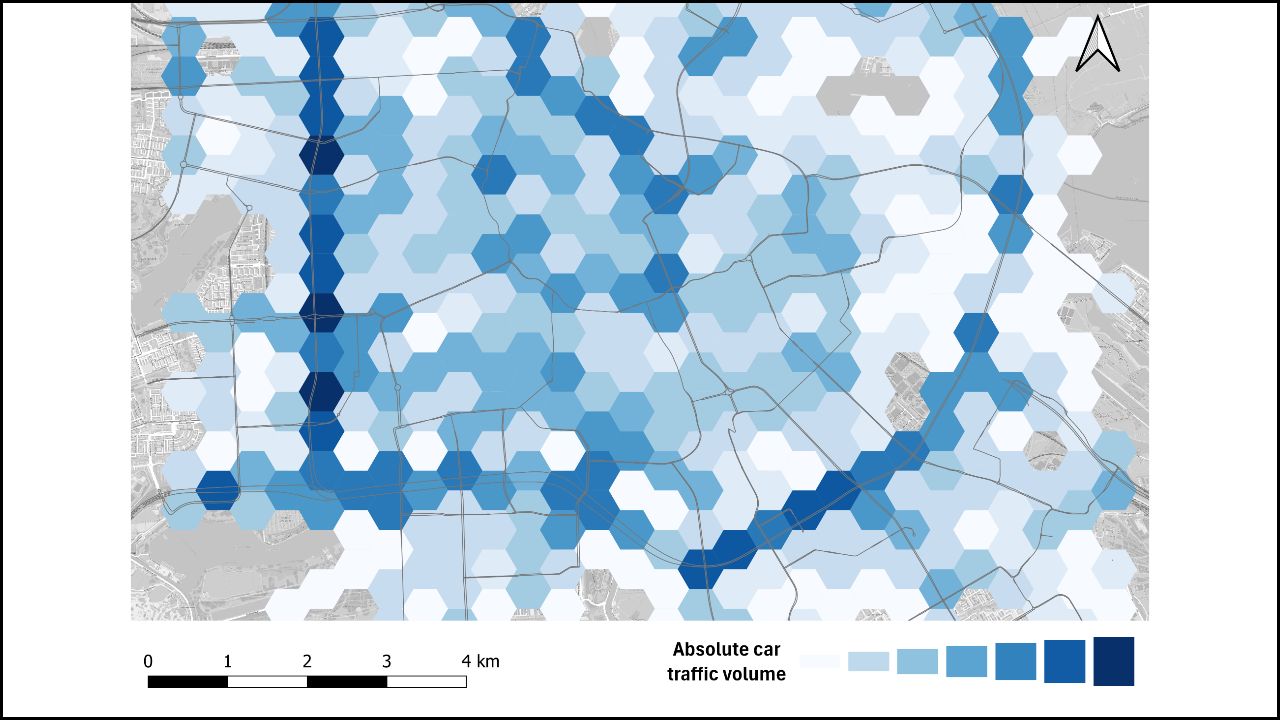
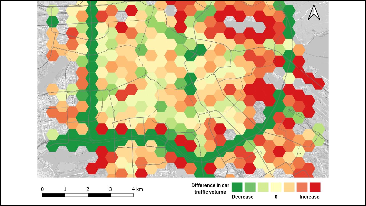
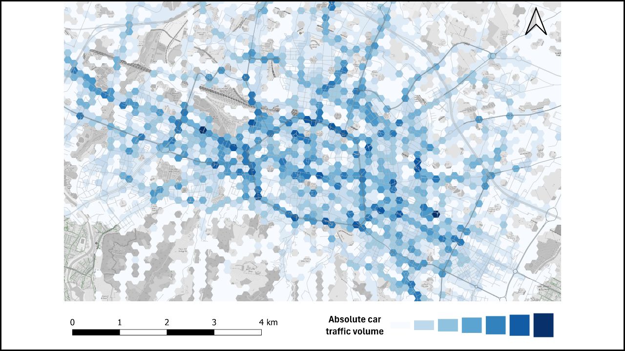
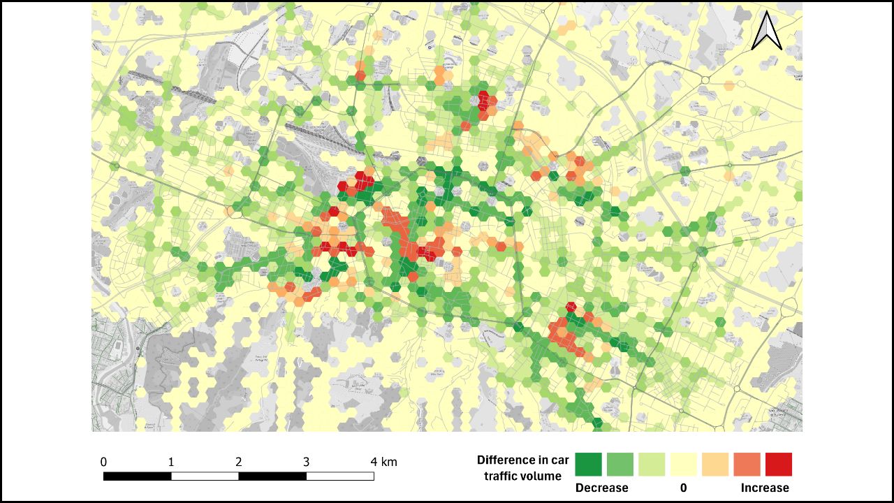
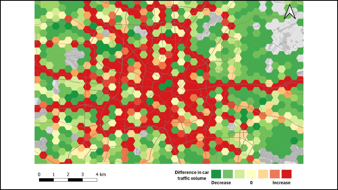
In a scenario where 35 streets are no longer accessible by cars, we see that areas with high car traffic are similar to the BAU scenario. Overall, there is a small decrease in car traffic as we can see in the modal split. On the map, we see that mainly the ring road is the area where there is the largest absolute decrease in car traffic. When looking at the difference between the two scenarios, mainly the southern and western parts of the inner ring have an increase in car traffic, whereas the inner-city remains more or less the same, with some slight differences. Remarkably, in Gentbrugge (southeast of the inner ring) a significant decrease in car traffic occurs. This can be attributed to a bridge that is closed for car traffic in this scenario. The modal suggests that implementing street closures in residential streets across the city, might result in a shift in car traffic from the city centre to the ring roads.
In a scenario where 35 streets are no longer accessible by cars, we see that areas with high car traffic are similar to the BAU scenario. Overall, there is a small decrease in car traffic as we can see in the modal split. On the map, we see that mainly the ring road is the area where there is the largest absolute decrease in car traffic. When looking at the difference between the two scenarios, mainly the southern and western parts of the inner ring have an increase in car traffic, whereas the inner-city remains more or less the same, with some slight differences. Remarkably, in Gentbrugge (southeast of the inner ring) a significant decrease in car traffic occurs. This can be attributed to a bridge that is closed for car traffic in this scenario. The modal suggests that implementing street closures in residential streets across the city, might result in a shift in car traffic from the city centre to the ring roads.
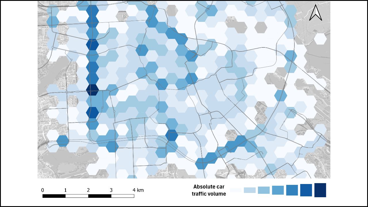
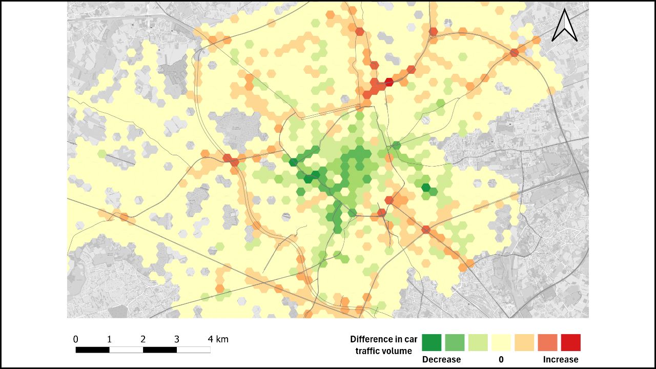
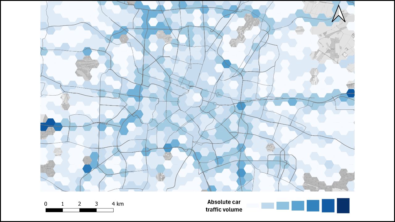
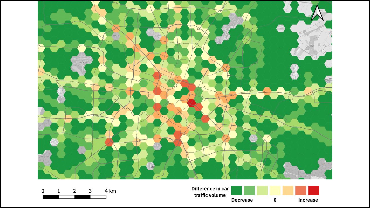
In the scenario with 65 street closures, similar patterns emerge with elevated car traffic in specific areas. Analogous with the previous scenario with 35 street closures, there is a decrease in car activity along the inner ring and arterial roads, coupled with a (small) increase in the inner-city. Notably, in comparison to the 35-street closure scenario, a more pronounced decrease in car traffic is observed in numerous neighbourhoods. Conversely, areas experiencing lowered car traffic seem to concentrate around specific key points on the R40.
In the scenario with 65 street closures, similar patterns emerge with elevated car traffic in specific areas. Analogous with the previous scenario with 35 street closures, there is a decrease in car activity along the inner ring and arterial roads, coupled with a (small) increase in the inner-city. Notably, in comparison to the 35-street closure scenario, a more pronounced decrease in car traffic is observed in numerous neighbourhoods. Conversely, areas experiencing lowered car traffic seem to concentrate around specific key points on the R40.
In the scenario with 65 street closures, similar patterns emerge with elevated car traffic in specific areas. Analogous with the previous scenario with 35 street closures, there is a decrease in car activity along the inner ring and arterial roads, coupled with a (small) increase in the inner-city. Notably, in comparison to the 35-street closure scenario, a more pronounced decrease in car traffic is observed in numerous neighbourhoods. Conversely, areas experiencing lowered car traffic seem to concentrate around specific key points on the R40.
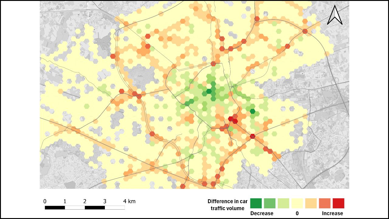


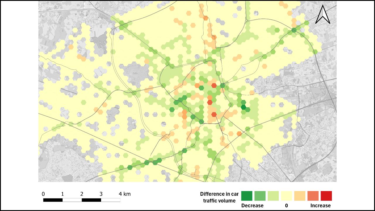
In this scenario where the 35 street closures are accompanied by car-sharing stations, concentrations of high car traffic occur in similar areas. The areas where there is a decrease in car traffic (green hexagons) are rather limited in this scenario. Instead, we see multiple hexagons with strong increases (red) and multiple areas with no increases (yellow) all around the city. It is clear that an increase of car usage has appeared in this scenario. This suggests that an increased uptake of car-sharing stations could lead to an rise in car traffic.
In this scenario where the 35 street closures are accompanied by car-sharing stations, concentrations of high car traffic occur in similar areas. The areas where there is a decrease in car traffic (green hexagons) are rather limited in this scenario. Instead, we see multiple hexagons with strong increases (red) and multiple areas with no increases (yellow) all around the city. It is clear that an increase of car usage has appeared in this scenario. This suggests that an increased uptake of car-sharing stations could lead to an rise in car traffic.
Generally, we see an increase in car traffic compared to the BAU-scenario. The areas where there is a decrease in car traffic (green hexagons) are rather limited in this scenario. We see multiple hexagons with strong increases (red) and multiple areas with no increase or decrease (yellow) all around the city. Compared to the scenario with 35 street closures, we can see a less pronounced increase in car traffic almost everywhere in the city. Only in some specific hexagons in the city centre a decrease has occurred.
Generally, we see an increase in car traffic compared to the BAU-scenario. The areas where there is a decrease in car traffic (green hexagons) are rather limited in this scenario. We see multiple hexagons with strong increases (red) and multiple areas with no increase or decrease (yellow) all around the city. Compared to the scenario with 35 street closures, we can see a less pronounced increase in car traffic almost everywhere in the city. Only in some specific hexagons in the city centre a decrease has occurred.
Generally, we see an increase in car traffic compared to the BAU-scenario. The areas where there is a decrease in car traffic (green hexagons) are rather limited in this scenario. We see multiple hexagons with strong increases (red) and multiple areas with no increase or decrease (yellow) all around the city. Compared to the scenario with 35 street closures, we can see a less pronounced increase in car traffic almost everywhere in the city. Only in some specific hexagons in the city centre a decrease has occurred.


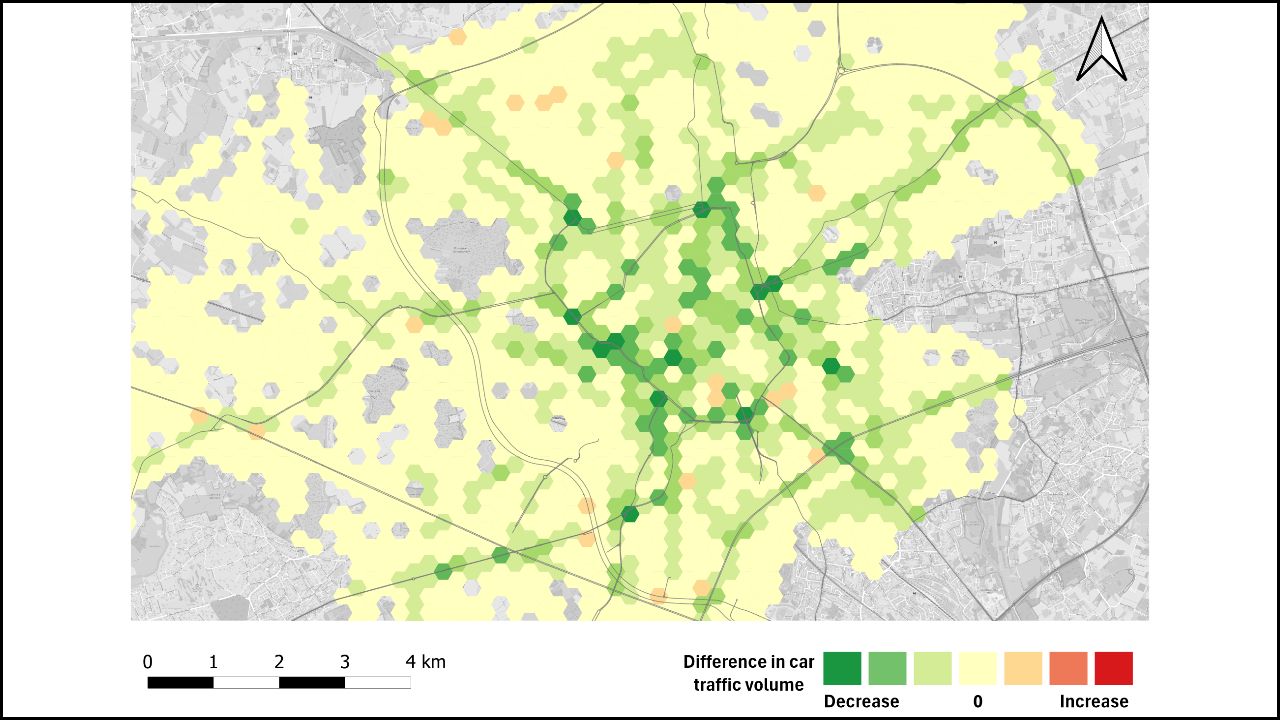
Closing 35 streets for car traffic and accompanying them with a bike-sharing station, generally results in small increase in bike traffic. Overall car traffic remains more or less the same, but some spatial difference can be noted. The areas where there is a strong decrease in car traffic (green hexagons) are very limited in this scenario. Rather, we see multiple hexagons with strong increases (red) and multiple areas with with no increase or decrease (white) both in the city centre and beyond. However, most increases are located within the inner ring road area and on some key-points along this road.
Closing 35 streets for car traffic and accompanying them with a bike-sharing station, generally results in small increase in bike traffic. Overall car traffic remains more or less the same, but some spatial difference can be noted. The areas where there is a strong decrease in car traffic (green hexagons) are very limited in this scenario. Rather, we see multiple hexagons with strong increases (red) and multiple areas with with no increase or decrease (white) both in the city centre and beyond. However, most increases are located within the inner ring road area and on some key-points along this road.
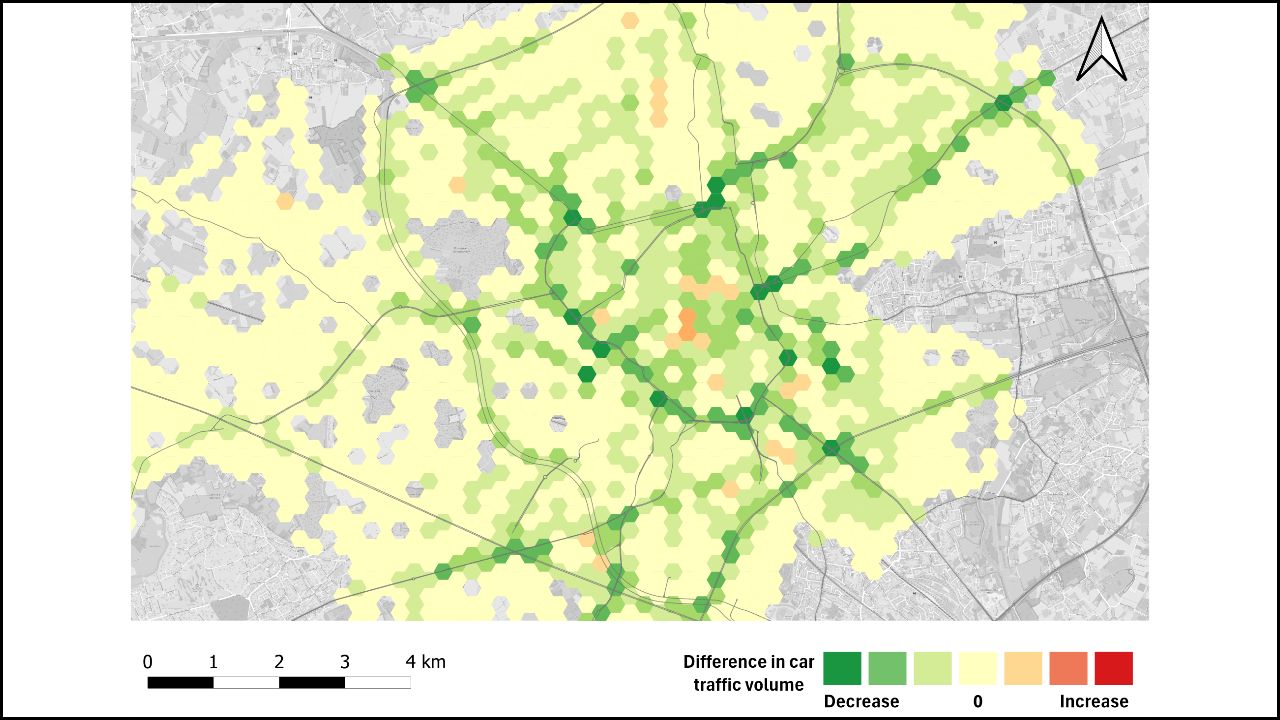
Overall, a small decrease in car traffic and a considerable increase in bicycle traffic can be witnessed in this scenario. The areas where there is a decrease in car traffic (green hexagons) are less limited here than for the other scenarios. These areas are located in the city centre and in Gentbrugge (because the Gentbrugge bridge is closed for car traffic). We also see multiple hexagons with strong increases (red) and multiple areas with moderate increases (orange), mostly located on the ring roads (southwest of city centre) and outside of the city centre. Compared to the scenario with 65 street closures we can see a decrease of car traffic and an increase of bike traffic. There are less areas with an increase in car travel. Overall, we can conclude that combining a higher amount of street closures with bike-sharing stations, results in an increase of bike traffic and a small increase of car traffic, mainly taking place in the city centre.
Overall, a small decrease in car traffic and a considerable increase in bicycle traffic can be witnessed in this scenario. The areas where there is a decrease in car traffic (green hexagons) are less limited here than for the other scenarios. These areas are located in the city centre and in Gentbrugge (because the Gentbrugge bridge is closed for car traffic). We also see multiple hexagons with strong increases (red) and multiple areas with moderate increases (orange), mostly located on the ring roads (southwest of city centre) and outside of the city centre. Compared to the scenario with 65 street closures we can see a decrease of car traffic and an increase of bike traffic. There are less areas with an increase in car travel. Overall, we can conclude that combining a higher amount of street closures with bike-sharing stations, results in an increase of bike traffic and a small increase of car traffic, mainly taking place in the city centre.
Overall, a small decrease in car traffic and a considerable increase in bicycle traffic can be witnessed in this scenario. The areas where there is a decrease in car traffic (green hexagons) are less limited here than for the other scenarios. These areas are located in the city centre and in Gentbrugge (because the Gentbrugge bridge is closed for car traffic). We also see multiple hexagons with strong increases (red) and multiple areas with moderate increases (orange), mostly located on the ring roads (southwest of city centre) and outside of the city centre. Compared to the scenario with 65 street closures we can see a decrease of car traffic and an increase of bike traffic. There are less areas with an increase in car travel. Overall, we can conclude that combining a higher amount of street closures with bike-sharing stations, results in an increase of bike traffic and a small increase of car traffic, mainly taking place in the city centre.
For the city of Bologna, we developed a series of MATSim scenarios based on a synthetic population of 25 000 inhabitants with hypothetical travel plans. Unlike to the case study of Ghent, the trips made by this synthetic population are only taking place inside of the city of Bologna. This means that traffic in some parts of the city, for example on the outer-ring road, is underrepresented.
For this city, only one hypothetical scenario was created. This was done in collaboration with the City of Bologna and the other EX-TRA project partners. The scenario involved the creation of several street experiments in combination with low-traffic streets (streets with limited car capacity). All these potential street interventions are situated near schools where the City of Bologna aims to enhance safety in the vicinity. This resulted in a total of 20 streets that were entirely closed off for car traffic and 35 streets where the car capacity flow was halved.
Bologna Tool Combination
Bologna was used as a case study to test the co-applicability of the three tools developed in the EX-TRA project (GOAT by Plan4Better, Munich and IAPI by PoliMi, Milan). In this analysis, we focused on school streets and their direct vicinity. Together with the City of Bologna, a number of neighbourhoods of interest was selected. The three tools analysed accessibility, walkability and car traffic in these neighbourhoods. Find out more here!
Relevant links:
Street closures
Street closures

For the city of Munich, we developed a series of MATSim scenarios based on a 22% synthetic population of 324 000 inhabitants with hypothetical travel plans. For this city, three hypothetical scenarios were created. These are similar to the ones of Ghent and Amsterdam, which allows to make a comparison over the different cities. In the first scenario, a total of 35 streets are closed off for car traffic. The second scenario depicts the same street closures combined with station based shared car stations near the closed streets. The third scenario depicts the same as the previous, but shared cars are replaced by free floating shared bikes.
Relevant links:
Street closures
Street closures


For the city of Amsterdam, we developed a series of MATSim scenarios based on a 18% synthetic population of 150 000 inhabitants with hypothetical travel plans. For this city, three hypothetical scenarios were created. These are similar to the ones of Ghent and Munich, which allows to make a comparison over the different cities. The three scenarios are respectively one where only 35 streets are closed off for car traffic. The second scenario depicts the same street closures combined with additional station based shared car stations near the closed streets. The third scenario depicts the same as the previous but instead of share cars, now shared bikes are present.
Relevant links:
Street closures
Street closures